Thank you to everyone who participated in the March 3 virtual information session.
Materials from the session are available below.
Feedback may be submitted until March 17, 2026.
Our Vision for RiverRidge
Imagine a community where breathtaking views of the Bow River blend with thoughtfully designed green spaces. RiverRidge offers a balanced lifestyle, combining nature’s tranquility with convenient access to shopping, recreation, and essential services.
Designed to be compact and pedestrian-friendly, RiverRidge integrates a variety of housing options with parks and green spaces that respect the area’s natural beauty.
In January 2026, Douglas Developments submitted an updated Neighbourhood Plan for RiverRidge. The team is currently working with Town of Cochrane administration to refine the plan, with the intention of presenting it to Council.
What is a Neighbourhood Plan?
Neighbourhood Plans provide a framework for the development of a community. It defines the community layout, the placement of parks, the built form, and transportation and servicing requirements.
The vision for RiverRidge is founded on the following Guiding Principles:
Aging in the Community and Lifecycle Housing
RiverRidge will provide housing for all ages and stages of life. Residents will benefit from proximity to existing and future schools, open spaces, commercial amenities, and direct access to the Bow River and pathway network. With River Heights Garden Residences Retirement located nearby, RiverRidge is a place where residents can remain comfortably through early years to retirement.
Missing Middle Housing
The community will include a range of housing options:
- Single detached homes
- Semi-detached homes
- Back-to-back townhomes
About 25% of housing options will provide alternatives typically underrepresented in new communities. This variety supports a diverse and resilient neighbourhood.
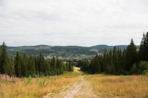
A Neighbourhood Nestled in Nature
RiverRidge is shaped by rolling hills and forested areas along the Bow River escarpment. The plan works with this natural landscape to minimize impacts and integrate with protected environmental areas.
Active Connections
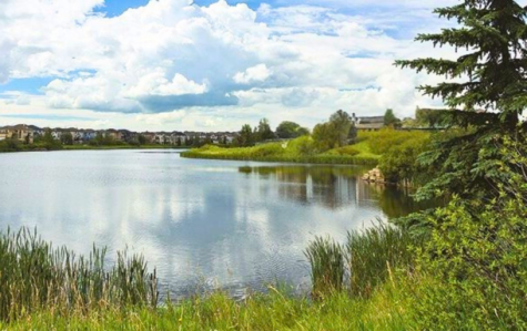
RiverRidge offers proximity and convenient access to the Bow River. Informal trails provide access today, and formal pathway connections are being coordinated with the Town.
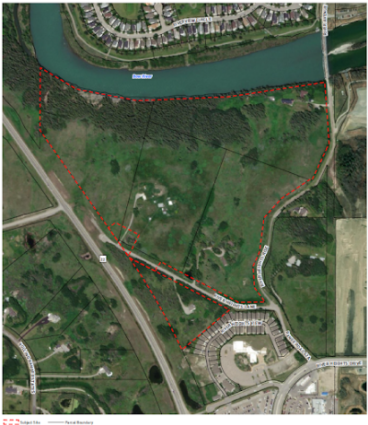
Introducing RiverRidge
RiverRidge is made up of four parcels totaling 78.28 acres and is located in southwest Cochrane within the River Heights Area Structure Plan. The community is bound by the Bow River to the north, Cowboy Trail (Hwy 22) to the west, River Heights Lane to the south, and River Heights Rise to the east. The subject land is currently a mix of country residential acreages and undeveloped Urban Holdings.
The northwest portion of the plan area remains designated as an urban land use area with no immediate development proposed.
What is a Structure Plan
The River Heights Area Structure Plan (ASP) is the statutory planning policy for this area. It establishes standards, policies, and expectations for all future development. To review the ASP, visit the Resources section.
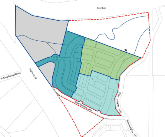
The Concept Plan
The proposed concept highlights the neighbourhood’s features, which are:
Environmental Reserve, Open Space, and Parks
RiverRidge includes Environmental Reserve areas that protect sensitive lands and provide natural amenities for residents.
The community’s open space network embraces the land’s unique topography, with strategically located parks that extend green connections, create view corridors, and support a distinct community identity.
The parks are proposed for the community:
Northwest Park
A 0.68 ha (1.68 ac) centrally located park adjacent to single-family and townhouse areas. Features include a fenced and gated dog park with gravel trail, playground, seating and picnic areas,
and open grass areas. Buffer plantings provide screening and transition to nearby homes.
East Park
A park with sweeping views of the Bow River and downtown Cochrane. Includes a large playground, seating, open lawn, and an entry feature at the southeast corner.
Central Park
A 0.26 ha (0.64 ac) park surrounded by residential development. Features include a playground, half basketball court, picnic and seating areas, open lawn, and buffer plantings.

Access
Primary access will be through Highway 22 and River Heights Drive (via River Heights Lane). River Heights Lane will be extended northwest through RiverRidge.
The new Highway 22 intersection will provide access westward to developing communities and northward to the heart of Cochrane, while also serving emergency services. With the River Heights Drive connection, residents will also have convenient access to James Walker Trail and south Cochrane.
Servicing
Preliminary studies for water, sanitary, and stormwater servicing have been completed. Further details will be provided at the detailed design stage.
Phasing
- Phase 1 – Southeast portion, connecting to River Heights Lane.
- Phase 2 – Northeast-central area, including access to the Lot 1 Special Study area and collector road to Highway 22.
- Phase 3 – Central area of the neighbourhood, with a mix of housing options.
- Phases 4 and 5 – West side of the plan, proposed as comprehensive townhouse developments.
Timeline

OCT 2011
River Heights Area Structure Plan Approved

September 2024
Initial Neighbourhood Plan Submitted

March 2025
Public Open House
January 2026
Plan Resubmitted

March 2026
Community update while application is under final review by the Town

Spring 2026
Anticipated Council consideration
All dates are estimates and subject to change based on Town approvals.
Get Involved

View materials from our March 2025 public open house
Access presentation boards and the engagement summary that documents what we heard and how feedback informed project updates.

Have questions of comments>
Email Jane Geller, Community Engagement Specialist at jgeller@bastudios.ca